Croft History
  • Home
  • Places of Worship
    • Croft Unitarian Chapel
    • Risley Presbyterian Chapel
    • Christ Church
    • St. Oswalds Church
    • Burial Grounds
  • Local Families
    • The Yates Family >
      • Philip Yates
      • Mary Yates
      • Samuel Yates
      • James Yates
      • Ellen Yates Junior
      • Richard Yates
      • Richard Yates Part 2
      • Richard Yates Part 3
      • Joseph Yates
      • Anne Yates Interview
    • The Clare, Warburton and Daintith Family
  • World War Two
  • Gallery
  • Public Houses
  • Contact
  • News

History
&
​Heritage

The Little Known Symbols on Lady Lane

1/1/2022

 
Many people choose Lady Lane in Croft as part of their local walk. Not many people will have noticed the symbols made up of straight lines that are carved into walls along the route. They are in fact bench marks.

What are bench marks?

Bench marks are the visible manifestation of Ordnance Datum Newlyn (ODN), which is the national height system for mainland Great Britain and forms the reference frame for heights above mean sea level.

Most commonly, the BMs are found on buildings or other semi-permanent features. Although the main network is no longer being updated, the record is still in existence and the markers will remain until they are eventually destroyed by redevelopment or erosion.

Where can I find the bench marks?

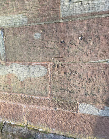
There are two bench marks on Lady Lane. One is at Croft Unitarian Chapel and one is at Christ Church.
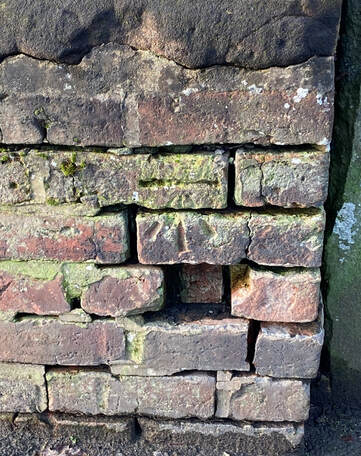
The bench mark at Croft Unitarian Chapel is on the boundary wall, which means it is not in its original position, as Warrington Borough Council have rebuilt the wall. (It does seem to be at the correct height above the ground level).
Picture
Bench mark at Croft Unitarian Chapel
Picture
Bench mark at Christ Church
Croft Unitarian Chapel Bench Mark

Description: 
WALL ENTRANCE BURIAL GROUND WEST SIDE LADY LANE SOUTH EAST ANGLE
Height: 22.8387m
Height above ground: 0.4m
Date verified: 1957

Christ Church Bench Mark

Description: 
CHURCH WEST FACE CHRIST CHURCH TOWER EAST SIDE LADY LANE
Height: 33.1592m
Height above ground: 1.2m
​Date verified: 1957


Comments are closed.

    Author

    Cheyvonne Bower is a local historian with a passion for the past.
    A member of
    ​Manchester & Lancashire Family History Society.

    Archives

    April 2023
    March 2023
    December 2022
    November 2022
    October 2022
    September 2022
    August 2022
    May 2022
    April 2022
    March 2022
    February 2022
    January 2022

    Categories

    All
    Christ Church
    Crime And Punishment
    Croft In The News
    Croft Then And Now
    Croft Unitarian Chapel
    Culcheth
    Health
    Irlam
    Leisure
    Listed Buildings
    Maps
    Newspapers
    On This Day
    People
    Public Houses
    Winwick

Picture
© Cheyvonne Bower 2023
  • Home
  • Places of Worship
    • Croft Unitarian Chapel
    • Risley Presbyterian Chapel
    • Christ Church
    • St. Oswalds Church
    • Burial Grounds
  • Local Families
    • The Yates Family >
      • Philip Yates
      • Mary Yates
      • Samuel Yates
      • James Yates
      • Ellen Yates Junior
      • Richard Yates
      • Richard Yates Part 2
      • Richard Yates Part 3
      • Joseph Yates
      • Anne Yates Interview
    • The Clare, Warburton and Daintith Family
  • World War Two
  • Gallery
  • Public Houses
  • Contact
  • News